Posts

Showing posts from August, 2020

Hurricane Laura made landfall

Image
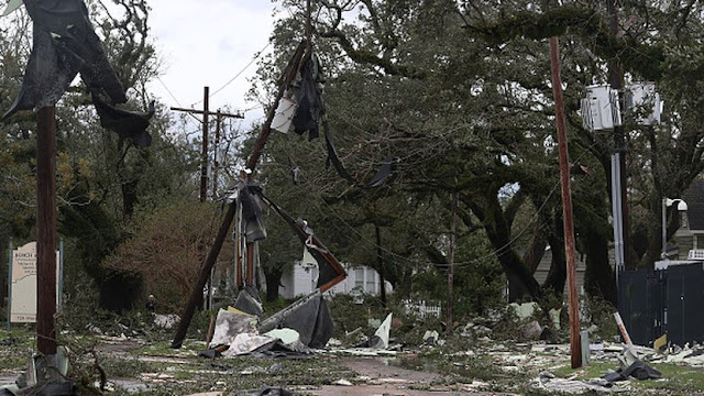
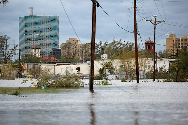
  Hurricane Laura made landfall just before 2 a.m. EDT Thursday near Cameron, Louisiana, as an “extremely dangerous” Category 4 storm with maximum sustained winds of 150 mph, according to officials with the National Weather Service’s National Hurricane Center. By 1 p.m. EDT, the storm had been downgraded to a tropical storm and later Thursday to a tropical depression, according to the NHC. Louisiana Gov. John Bel Edwards on Thursday confirmed that at least four people have died as a result of Hurricane Laura, including a 14-year-old near Leesville, a 60-year-old in Acadia Parish and two others in Jackson and Vernon parishes. Here are the latest updates: Update 2 a.m. EDT Aug. 28:  Live updates on this storm system have concluded. Update 10:54 p.m. EDT Aug. 27:  Laura was downgraded to a tropical depression as it continued to caused flooding threats as it moved through Arkansas. In its 11 p.m. EDT advisory, the National Hurricane Center said the center of the storm was located 30 miles

Storm Laura batters

Image
  Hurricane Laura knocked out most of the water service in Lake Charles, Louisiana, Thursday. “We’ve got some plants that are open, but it’s not enough to serve the entire city. The pressure is in the single digits,” City Administrator John Cardone told CNN. Cardone said engineering consultants are coming to the city to help fix the system, which they hope to have to at least 45% capacity on Friday. The problem, according to the city administrator, is not just a loss of power, but also the potential for broken pipes all over the city. “There were a lot of uprooted trees on private property,” said Cardone. “If they got the water lines on the private property, we’d need to go there and locate it. If people are evacuated, we don’t know where the leaks are.” The US Centers for Disease Control and Prevention issued a Health Alert Network advisory Thursday warning of the risks of carbon monoxide poisoning in the aftermath of Hurricane Laura, which slammed into the Louisiana coast early Thurs

Hurricane Laura landfall

Image
  At 1 am CDT, Hurricane Laura has made landfall in southwestern Louisiana near Cameron as a category 4 hurricane. Maximum sustained winds were 150 mph, with a minimum central pressure of 938 mb. Potentially catastrophic impacts will continue. Authorities implored coastal residents of Texas and Louisiana to evacuate, but not everyone did before winds began buffeting trees back and forth in an area that was devastated by Rita in 2005. The storm grew nearly 87% in power in just 24 hours to a size the National Hurricane Center called "extremely dangerous." Drawing energy from the warm Gulf of Mexico, the system was on track to arrive early Thursday during high tide as the most powerful hurricane to strike the U.S. so far this year. "It looks like it's in full beast mode, which is not what you want to see if you're in its way," University of Miami hurricane researcher Brian McNoldy said. Hurricane-force winds extending 60 miles (95 kilometers) from the storm'

storm surges in Louisiana and Texas

Image
  Hurricane Laura   continued to strengthen late Wednesday as it approached the Louisiana coastline, reaching a wind speed just shy of that of a Category 5 storm. Forecasters say Laura could cause an ‘unsurvivable’ storm surge. A Category 5 hurricane has never hit the coast of that state, CNN meteorologist Brandon Miller said. Hurricane Katrina had that strength in the Gulf but was downgraded before it made landfall in 2005. Laura was moving over the Gulf of Mexico with maximum sustained winds of 150 mph, about 90 miles   south of Lake Charles, Louisiana, and it could strengthen even more before making landfall near the Texas border, forecast for shortly after midnight local time. With top winds of 150 mph, Laura is a high-end  Category 4 , only 7 mph below a Category 5 hurricane. "Sustained tropical-storm-force winds and steady heavy rains (are) beginning to spread onshore the central Louisiana coast,"  the NHC said  in an update Wednesday evening. Water levels along the Lou